

Northern Tenerife
Cordillera Dorsal
A volcanic mountain ridge crossing central-eastern Tenerife, with forests, high roads and shifting cloudscapes.
About this place
Cordillera Dorsal, also called the Pedro Gil ridge, forms a long mountainous spine through the central-eastern part of Tenerife. Its elevated volcanic terrain links the island’s upper forest landscapes with roads and routes toward the Teide highlands.
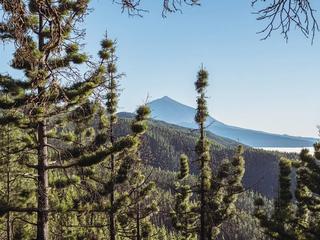
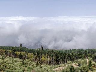
The ridge helps explain the striking changes in Tenerife’s weather and vegetation. Moist trade winds can collect cloud on windward slopes while clearer conditions prevail elsewhere, and pine woodland occupies broad sections of the uplands.
The Cordillera Dorsal is a geographical formation, not a single staffed attraction or one designated viewpoint. Plan visits around officially signposted lookouts, public roads and permitted trails, rather than treating the existing map point as a trailhead.
Mountain temperatures and visibility can change quickly. Check official road and trail restrictions, prepare for cool or wet weather and never stop on exposed bends for photographs. Respect forest fire rules and protected habitats.
Explore nearby Paisaje protegido de Las Lagunetas and Barranco Hondo for more local context and planning information.
Visitor information
This is a mountain range rather than a single visitor entrance. Use designated viewpoints and official trails; check road closures, mountain weather and forest restrictions.
Location
Explore nearby
Places close to Cordillera Dorsal, sorted by distance.

Paisaje protegido de Las Lagunetas
Northern Tenerife
Explore Las Lagunetas, a protected Tenerife forest landscape with pine woodland and native mountain vegetation.
Ortuño Viewpoint
Teide & Central Tenerife
A classic stop on the La Esperanza road to Teide, known for views of the volcano, forest and sea of clouds.
Northern Tenerife
Las Calderetas is an officially designated camping area (zona de acampada) within Paisaje Protegido de Las Lagunetas, in the municipality of El Sauzal in northern Tenerife. It sits in a managed forest/natural setting typical of the island's authorised camping zones, which are overseen by the Cabildo de Tenerife. It is officially listed for tent and cabin camping. As with every zona de acampada in Tenerife, you need a free permit arranged in advance through the Cabildo (Tenerife ON), and stays are capped at a maximum of seven consecutive days. On-site facilities vary and are not guaranteed, so confirm current rules, availability and any fire or weather closures on the official channel before you travel.

La Matanza de Acentejo
Northern Tenerife
La Matanza de Acentejo is a town near the north coast of Tenerife, Canary Islands, Spain. It is located 10 km east of Puerto de la Cruz, and about 20 km west of the island's capital, Santa Cruz de Tenerife.
Santa Cruz & La Laguna
Las Raíces is an officially designated camping area (zona de acampada) within Paisaje Protegido de Las Lagunetas, in the municipality of El Rosario in metropolitan Tenerife. It sits in a managed forest/natural setting typical of the island's authorised camping zones, which are overseen by the Cabildo de Tenerife. The official listing covers both tent/cabin and motorhome/caravan camping. As with every zona de acampada in Tenerife, you need a free permit arranged in advance through the Cabildo (Tenerife ON), and stays are capped at a maximum of seven consecutive days. On-site facilities vary and are not guaranteed, so confirm current rules, availability and any fire or weather closures on the official channel before you travel.

Montaña Grande Mountain Viewpoint
Teide & Central Tenerife
A pine-forest viewpoint on the TF-24, opening from the high road toward Tenerife’s mountain landscape.

Las Rosas
Eastern Tenerife
Visit Las Rosas, a historic rural community in El Rosario municipality, Tenerife.

El Rosario, Tenerife
Northern Tenerife
El Rosario is a municipality in the northeastern part of the island of Tenerife in the Santa Cruz de Tenerife province, on the Canary Islands, Spain.
Chivisaya Viewpoint
Eastern Tenerife
A viewpoint over the Güímar Valley, looking across farmland, settlements and the broad eastern slope of Tenerife.
Eastern Tenerife
A south-facing mountain viewpoint over Arafo’s upper slopes and volcanic highland scenery.

La Victoria de Acentejo
Northern Tenerife
La Victoria de Acentejo is a town and a municipality in the northern part of the island Tenerife, Canary Islands, Spain.

Barranco Hondo
Eastern Tenerife
neighborhood of the municipality of Candelaria, Santa Cruz de Tenerife

